
From point cloud to model in ELITE CAD! Smart and efficient!
ELITECAD: Efficient integration and management of 3D point clouds in CAD projects .
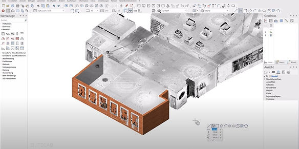
Point clouds are a fundamental element in modern surveying and 3D modeling, primarily enabled by advanced 3D laser scanning technology. ELITECAD is a powerful CAD software that enables architects, engineers, and designers to efficiently integrate point clouds into their projects.
Integrating point clouds into ELITECAD begins with importing data captured by 3D laser scanners. This data can be in a variety of formats, with ELITECAD offering user-friendly support for common formats such as E57, LAS, LAZ, and even raw text files. This flexibility allows users to acquire point cloud data from a variety of sources, including powerful scanning software such as FARO Scene, which provides excellent export capabilities for such data-rich files.


After the point cloud is imported, it appears as an object in the software that can be further edited. Points can be selected, measured, or deleted, and point clouds can be split or merged.
ELITECAD offers a batch import feature for importing multiple point clouds simultaneously. This allows you to import multiple files from a single folder, saving time and improving efficiency, provided all files refer to the same source.
ELITECAD gives users the ability to customize details in the display. For example, informational text can be displayed for the points, which can be helpful for orientation and contextualizing the data. The size of the points can also be adjusted to optimize readability on screen and in the planning. These settings can be found in the menu under "SETTINGS > OPTIONS > DISPLAY 2D/3D."
In summary, ELITECAD is a powerful tool that handles the complexity and size of point cloud data through robust import capabilities and intelligent data management features – a must-have for any professional working in 3D surveying and modeling. With support for formats from a variety of sources, such as the professional scanning software FARO Scene, ELITECAD represents an influential combination of precision and performance in the world of 3D design.
Finally, we would like to assure you that this is only a first glimpse into the diverse possibilities of laser scanning and construction. If you are interested in further development or have specific questions about your project, please do not hesitate to contact us. The team at www.Laserscanner.info is always available to provide comprehensive support and meet your individual requirements. A heartfelt thank you also goes to Laserscanning Experts (www.laserscanning-experts.de) , whose expertise and willingness to share information contributed significantly to the success of this overview. We are always here to assist you with all your laser scanning and construction needs.