
Autodesk Revit
Working with 3D laser scanners and point clouds in Revit
Autodesk Revit is software for planning and managing construction and infrastructure projects. Its focus is on modeling buildings and infrastructure and providing comprehensive project management. By leveraging the BIM (Building Information Modeling) methodology, Revit creates a high level of clarity and visualization of the entire project. This methodology is particularly valuable through the integration of laser scanning and point clouds as a base model.
1. Importing the point cloud in .rcp/.rcs format and how to align it
Die Einbindung von Punktwolken in Autodesk Revit beginnt mit dem Import der Punktwolke im .rcp bzw. .rcs Format. Nach dem Import kann die Punktwolke als dreidimensionale Referenz für das Architekturmodell genutzt werden. Um eine genaue Ausrichtung der Punktwolke zu ermöglichen, können bestimmte Punkte im Modell und in der Punktwolke definiert und anschließend miteinander verknüpft werden. Hierdurch wird das Basis-Modell präzise ausgerichtet und bietet eine solide Grundlage für die Konstruktion und Gestaltung von Gebäuden und Infrastrukturen.
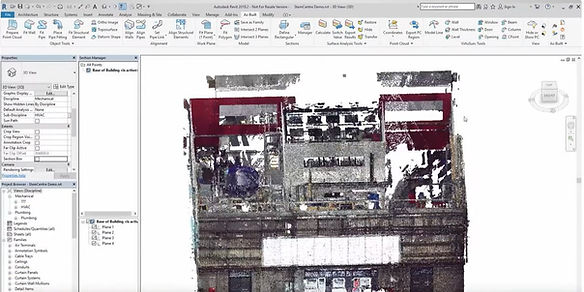
2. The point cloud as a basis for floor plans and 3D models
Using the point cloud as a basis enables the rapid and precise creation of floor plans and 3D models. This is particularly valuable in the field of serial renovations. Laser scanners can be used to quickly capture the building and spatial structure. With an accuracy of 1 to 2 millimeters, precise visualization and modeling is possible. This makes the BIM methodology, in combination with laser scanning and point clouds, an irreplaceable tool in modern architecture and the construction industry.
3. AS Built and how the point cloud can help
AS Built documents the actual, as-built state of a building. Using the point cloud, deviations from the original plan can be quickly and accurately recorded. This information is not only important for final documentation but also helps avoid delays and complications during the project.

The point cloud in Autodesk Revit is a powerful tool for quality assurance and clash detection in construction and renovation projects.
To ensure the quality of a construction and work without collisions, an accurate representation of the structural conditions is essential. It is important to keep an eye on both the approved planning model and the actual condition of the construction site. The point cloud enables a precise 3D representation of the actual structural conditions and is therefore an ideal comparison for the planned state of the model in Revit.
Specifically, the clash check in Revit works by directly comparing the data from the virtual model with the data from the point cloud. Conflicts between the two can be automatically detected. Depending on the type of conflict, Revit highlights potential problem areas and logs corresponding information about their type and location in the model. Once all clashes have been identified, the planner can correct the problems accordingly.
In this way, conflicts between different disciplines, such as building services and structural engineering, or between the model and reality, such as in the case of existing structures, can be identified and resolved during the planning phase. Early detection of potential clashes avoids costly and time-consuming changes during the construction phase.
Furthermore, the point cloud can be used for quality assurance. As part of as-built monitoring, i.e., the documentation of the actual construction status, the scan data can be compared with the originally planned model. Deviations are identified quickly and easily, which contributes to the quality assurance of the building project.

Overall, the use of the point cloud in Autodesk Revit for clash detection and quality assurance has a significant impact on the success of building projects - it saves time, money and resources and increases the quality, safety and efficiency of construction.
There are a variety of different laser scanners on the market, both mobile and stationary. Mobile scanners such as the Faro Orbis and BLK2Go are particularly suitable for building modeling, while stationary scanners such as the Faro Focus Core and Faro Focus Premium are of particular interest for high-resolution applications such as building services engineering.
In conclusion, the integration of laser scanning and point clouds into the BIM methodology represents a tremendous benefit for the construction industry. It enables precise, fast, and efficient project planning and execution. Both mobile scanners such as the Faro Orbis and Leica BLK2Go, as well as stationary scanners such as the Faro Focus Core and Faro Focus Premium, are recommended.
Finally, we would like to assure you that this is only a first glimpse into the diverse possibilities of laser scanning and construction. If you are interested in further development or have specific questions about your project, please do not hesitate to contact us. The team at www.Laserscanner.info is always available to provide comprehensive support and meet your individual requirements. A heartfelt thank you also goes to Laserscanning Experts (www.laserscanning-experts.de) , whose expertise and willingness to share information contributed significantly to the success of this overview. We are always here to assist you with all your laser scanning and construction needs.